Wednesday, 21 July 2021


LATEST NEWS
InSight Deploys Its Instruments
Journey to the Center of Mars With the InSight Lander Team

Scientists will talk about new findings in a question-and-answer session with the news media and public.

Scientists working with NASA’s InSight Mars lander will share new results in a virtual discussion at 9 a.m. PDT (12 p.m. EDT) on July 23. Since InSight landed on Mars in November 2018 its seismometer has detected hundreds of quakes. The InSight mission is helping teach scientists how all rocky planets – including Earth – formed.

The discussion will be livestreamed on NASA Television, the NASA app, the agency’s website, and multiple agency social media platforms, including the JPL YouTube and Facebook channels.

Speakers will include the following InSight science team members:

  • Mark Panning, NASA’s Jet Propulsion Laboratory in Southern California
  • Amir Khan, ETH Zurich and University of Zurich
  • Sabine Stanley, Johns Hopkins University

Members of the news media and public can submit questions using the hashtag #ASKNASA.

Earlier this year, the mission was extended for two years, running through December 2022.

Follow the InSight mission on Twitter at @NASAInSight for updates.

More About the Mission

JPL manages InSight for NASA's Science Mission Directorate. InSight is part of NASA's Discovery Program, managed by the agency's Marshall Space Flight Center in Huntsville, Alabama. Lockheed Martin Space in Denver built the InSight spacecraft, including its cruise stage and lander, and supports spacecraft operations for the mission.

A number of European partners, including France's Centre National d'Études Spatiales (CNES) and the German Aerospace Center (DLR), are supporting the InSight mission. CNES provided the Seismic Experiment for Interior Structure (SEIS) instrument to NASA, with the principal investigator at IPGP (Institut de Physique du Globe de Paris). Significant contributions for SEIS came from IPGP; the Max Planck Institute for Solar System Research (MPS) in Germany; the Swiss Federal Institute of Technology (ETH Zurich) in Switzerland; Imperial College London and Oxford University in the United Kingdom; and JPL. DLR provided the Heat Flow and Physical Properties Package (HP3) instrument, with significant contributions from the Space Research Center (CBK) of the Polish Academy of Sciences and Astronika in Poland. Spain's Centro de Astrobiología (CAB) supplied the temperature and wind sensors.

< >


LATEST NEWS
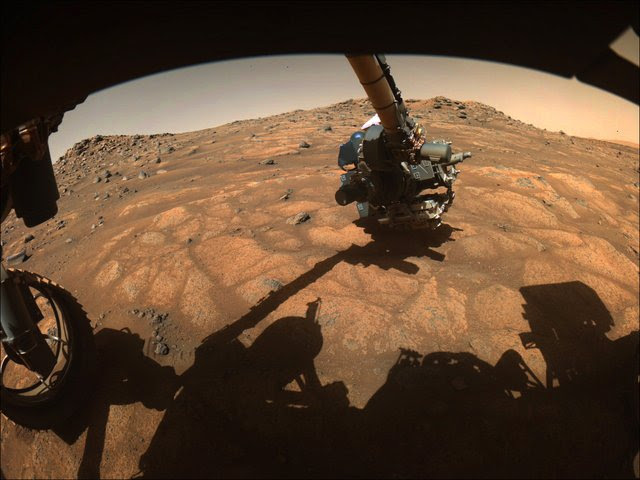
The robotic arm on NASA’s Perseverance rover reached out to examine rocks in an area on Mars nicknamed the “Cratered Floor Fractured Rough” area in this image captured on July 10, 2021 (the 138th sol, or Martian day, of its mission).
Signs of Life on Mars? NASA’s Perseverance Rover Begins the Hunt

After testing a bristling array of instruments on its robotic arm, NASA’s latest Mars rover gets down to business: probing rocks and dust for evidence of past life.

NASA’s Mars 2020 Perseverance rover has begun its search for signs of ancient life on the Red Planet. Flexing its 7-foot (2-meter) mechanical arm, the rover is testing the sensitive detectors it carries, capturing their first science readings. Along with analyzing rocks using X-rays and ultraviolet light, the six-wheeled scientist will zoom in for closeups of tiny segments of rock surfaces that might show evidence of past microbial activity.

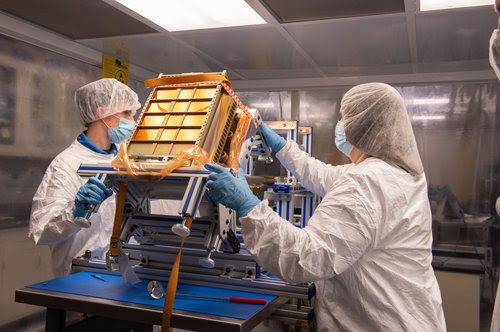
Called PIXL, or Planetary Instrument for X-ray Lithochemistry, the rover’s X-ray instrument delivered unexpectedly strong science results while it was still being tested, said Abigail Allwood, PIXL’s principal investigator at NASA’s Jet Propulsion Laboratory in Southern California. Located at the end of the arm, the lunchbox-size instrument fired its X-rays at a small calibration target – used to test instrument settings – aboard Perseverance and was able to determine the composition of Martian dust clinging to the target.

“We got our best-ever composition analysis of Martian dust before it even looked at rock,” Allwood said.

That’s just a small taste of what PIXL, combined with the arm’s other instruments, is expected to reveal as it zeroes in on promising geological features over the weeks and months ahead.

Scientists say Jezero Crater was a crater lake billions of years ago, making it a choice landing site for Perseverance. The crater has long since dried out, and the rover is now picking its way across its red, broken floor.

“If life was there in Jezero Crater, the evidence of that life could be there,” said Allwood, a key member of the Perseverance “arm science” team.

To get a detailed profile of rock textures, contours, and composition, PIXL’s maps of the chemicals throughout a rock can be combined with mineral maps produced by the SHERLOC instrument and its partner, WATSON. SHERLOC – short for Scanning Habitable Environments with Raman & Luminescence for Organics & Chemicals – uses an ultraviolet laser to identify some of the minerals in the rock, while WATSON takes closeup images that scientists can use to determine grain size, roundness, and texture, all of which can help determine how the rock was formed.

Early WATSON closeups have already yielded a trove of data from Martian rocks, the scientists said, such as a variety of colors, sizes of grains in the sediment, and even the presence of “cement” between the grains. Such details can provide important clues about formation history, water flow, and ancient, potentially habitable Martian environments. And combined with those from PIXL, they can provide a broader environmental and even historical snapshot of Jezero Crater.

“What is the crater floor made out of? What were the conditions like on the crater floor?” asks Luther Beegle of JPL, SHERLOC’s principal investigator. “That does tell us a lot about the early days of Mars, and potentially how Mars formed. If we have an idea of what the history of Mars is like, we’ll be able to understand the potential for finding evidence of life.”

The Science Team

While the rover has significant autonomous capabilities, such as driving itself across the Martian landscape, hundreds of earthbound scientists are still involved in analyzing results and planning further investigations.

“There are almost 500 people on the science team,” Beegle said. “The number of participants in any given action by the rover is on the order of 100. It’s great to see these scientists come to agreement in analyzing the clues, prioritizing each step, and putting together the pieces of the Jezero science puzzle.”

That will be critical when the Mars 2020 Perseverance rover collects its first samples for eventual return to Earth. They’ll be sealed in superclean metallic tubes on the Martian surface so that a future mission could collect them and send back to the home planet for further analysis.

Despite decades of investigation on the question of potential life, the Red Planet has stubbornly kept its secrets.

“Mars 2020, in my view, is the best opportunity we will have in our lifetime to address that question,” said Kenneth Williford, the deputy project scientist for Perseverance.

The geological details are critical, Allwood said, to place any indication of possible life in context, and to check scientists’ ideas about how a second example of life’s origin could come about.

Combined with other instruments on the rover, the detectors on the arm, including SHERLOC and WATSON, could make humanity’s first discovery of life beyond Earth.

More About the Mission

A key objective for Perseverance’s mission on Mars is astrobiology, including the search for signs of ancient microbial life. The rover will characterize the planet’s geology and past climate, pave the way for human exploration of the Red Planet, and be the first mission to collect and cache Martian rock and regolith (broken rock and dust).

Subsequent NASA missions, in cooperation with ESA (European Space Agency), would send spacecraft to Mars to collect these sealed samples from the surface and return them to Earth for in-depth analysis.

The Mars 2020 Perseverance mission is part of NASA’s Moon to Mars exploration approach, which includes Artemis missions to the Moon that will help prepare for human exploration of the Red Planet.

JPL, which is managed for NASA by Caltech in Pasadena, California, built and manages operations of the Perseverance rover.

For more about Perseverance:

mars.nasa.gov/mars2020/

and

nasa.gov/perseverance

Tuesday, 20 July 2021


Information about the Space Flight of Jeff Bezos (https://www.youtube.com/watch?v=ZlP2JA4DbBA)


ලොව ධනවත්ම පුද්ගලයා වන ජෙෆ් බෙසෝස් අද දින තමාගේම රොකට්ටුවක නැගී අභ්‍යවකාශය කරා ගමන් කිරීමට නියමිතයි. ඒ වගේම ඔහුත් සමග ලොව ලාබාලතම සහ වයස්ගතම අවකාශගාමීන් දෙදෙනාද ගමන් කරනු ඇති. මෙලෙස සුවිශේෂී මෙම අභ්‍යවකාශ ගමන ගැන මෙයින් විස්තර වනවා. Jeff Bezos space flight. blue origin. new shepherd. human space flight. going to space. SpaceX. virgin galactic. Blue origin. astronomy sinhala. science sinhala. sinhala science video. physics sinhala. vishwaya sinhalen. #astronomysinhala #sciencesinhala #educationsinhala #physicssinhala


Credit should go to,

Virgin Galactic

Blue Origin

----------------

You can save this video with our new @download_it_bot (https://t.me/download_it_bot?start=aximobot_caption)

Thursday, 15 July 2021


LATEST NEWS
Image of Jupiter's moon, Ganymede

Ride With Juno As It Flies Past the Solar System’s Biggest Moon and Jupiter

The probe flew closer to Jupiter's largest moon, Ganymede, than any other spacecraft in more than two decades, offering dramatic glimpses of both the icy orb and the gas giant.

On June 7, 2021, NASA’s Juno spacecraft flew closer to Jupiter’s ice-encrusted moon Ganymede than any spacecraft in more than two decades. Less than a day later, Juno made its 34th flyby of Jupiter, racing over its roiling atmosphere from pole to pole in less than three hours. Using the spacecraft’s JunoCam imager, the mission team has put together this animation to provide a “starship captain” point of view of each flyby.

“The animation shows just how beautiful deep space exploration can be,” said Scott Bolton, principal investigator for Juno from the Southwest Research Institute in San Antonio. “The animation is a way for people to imagine exploring our solar system firsthand by seeing what it would be like to be orbiting Jupiter and flying past one of its icy moons. Today, as we approach the exciting prospect of humans being able to visit space in orbit around Earth, this propels our imagination decades into the future, when humans will be visiting the alien worlds in our solar system.”

The 3:30-minute-long animation begins with Juno approaching Ganymede, passing within 645 miles (1,038 kilometers) of the surface at a relative velocity of 41,600 mph (67,000 kph). The imagery shows several of the moon’s dark and light regions (darker regions are believed to result from ice sublimating into the surrounding vacuum, leaving behind darkened residue) as well as the crater Tros, which is among the largest and brightest crater scars on Ganymede.

It takes just 14 hours, 50 minutes for Juno to travel the 735,000 miles (1.18 million kilometers) between Ganymede and Jupiter, and the viewer is transported to within just 2,100 miles (3,400 kilometers) above Jupiter’s spectacular cloud tops. By that point, Jupiter’s powerful gravity has accelerated the spacecraft to almost 130,000 mph (210,000 kph) relative to the planet.

Among the Jovian atmospheric features that can be seen are the circumpolar cyclones at the north pole and five of the gas giant’s “string of pearls” – eight massive storms rotating counterclockwise in the southern hemisphere that appear as white ovals. Using information that Juno has learned from studying Jupiter’s atmosphere, the animation team simulated lightning one might see as we pass over Jupiter’s giant thunderstorms.

The camera’s point of view for this time-lapse animation was generated by citizen scientist Gerald Eichstädt, using composite images of Ganymede and Jupiter. For both worlds, the JunoCam images were orthographically projected onto a digital sphere, and then synthetic frames were added between actual images to make the motion appear smoother and provide views of approach and departure for both Ganymede and Jupiter.

As planned, the gravitational pull of the giant moon has affected Juno’s orbit, resulting in the reduction of its orbital period from 53 days to 43 days. The next flyby of Jupiter, the 35th of the mission, is scheduled for July 21.

More About the Mission

JPL, a division of Caltech in Pasadena, California, manages the Juno mission for the principal investigator, Scott J. Bolton, of the Southwest Research Institute in San Antonio. Juno is part of NASA’s New Frontiers Program, which is managed at NASA’s Marshall Space Flight Center in Huntsville, Alabama, for the agency’s Science Mission Directorate in Washington. Lockheed Martin Space in Denver built and operates the spacecraft.

More information about Juno is available at:

https://www.nasa.gov/juno

https://www.missionjuno.swri.edu

Follow the mission on Facebook and Twitter at:

https://www.facebook.com/NASASolarSystem

https://www.twitter.com/NASASolarSystem

Wednesday, 14 July 2021


LATEST NEWS
The purple hues in this image show X-ray emissions from Jupiter’s auroras, detected by NASA’s Chandra Space Telescope in 2007.
40-Year Mystery Solved: Source of Jupiter’s X-Ray Flares Uncovered

A puzzler about the gas giant’s intense northern and southern lights has been deciphered.

Planetary astronomers combined measurements taken by NASA’s Juno spacecraft orbiting Jupiter, with data from ESA’s (the European Space Agency’s) Earth-orbiting XMM-Newton mission, to solve a 40-year-old mystery about the origins of Jupiter’s unusual X-ray auroras. For the first time, they have seen the entire mechanism at work: The electrically charged atoms, or ions, responsible for the X-rays are “surfing” electromagnetic waves in Jupiter’s magnetic field down into the gas giant’s atmosphere.

A paper on the study was published on July 9 in the journal Science Advances.

Auroras have been detected on seven planets in our solar system. Some of these light shows are visible to the human eye; others generate wavelengths of light we can only see with specialized telescopes. Shorter wavelengths require more energy to produce. Jupiter has the most powerful auroras in the solar system and is the only one of the four giant planets with an aurora that has been found to emit X-rays.

Planetary astronomers have been fascinated with Jupiter’s X-ray auroral emission since its discovery four decades ago because it was not immediately clear how the energy required to produce it is generated. They knew these surprising Jovian northern and southern lights are triggered by ions crashing into Jupiter’s atmosphere. But until now scientists had no idea how the ions responsible for the X-ray light show are able to get to the atmosphere in the first place.

At Earth, auroras are usually visible only in a belt surrounding the magnetic poles, between 65 and 80 degrees latitude. Beyond 80 degrees, auroral emission disappears because the magnetic field lines leave Earth and connect to the magnetic field in the solar wind, which is the constant flux of electrically charged particles ejected by the Sun. These are called open field lines, and in the traditional picture, Jupiter’s and Saturn’s high-latitude polar regions are not expected to emit substantial auroras, either.

However, Jupiter’s X-ray auroras are different. They exist poleward of the main auroral belt and pulsate, and those at the north pole often differ from those at the south pole. These are typical features of a closed magnetic field, where the magnetic field line exits the planet at one pole and reconnects with the planet at the other. All planets with magnetic fields have both open and closed field components.

Scientists studying the phenomena turned to computer simulations and found that the pulsating X-ray auroras could be linked to closed magnetic fields that are generated inside Jupiter and then stretch out millions of miles into space before turning back. But how to prove the model was viable?

The study authors turned to data acquired by both Juno and XMM-Newton from July 16 to 17, 2017. During the two-day span, XMM-Newton observed Jupiter continuously for 26 hours and saw X-ray aurora pulsating every 27 minutes.

At the same time, Juno had been traveling between 62 and 68 Jupiter radii (about 2.8 to 3 million miles, or 4.4 to 4.8 million kilometers) above the planet’s pre-dawn area. This was exactly the region that the team’s simulations suggested was important for triggering the pulsations, so they searched the Juno data for any magnetic processes that were occurring at the same rate.

They found that fluctuations of Jupiter’s magnetic field caused the pulsating X-ray auroras. The outer boundary of the magnetic field is struck directly by the particles of the solar wind and compressed. These compressions heat ions that are trapped in Jupiter’s extensive magnetic field, which are millions of miles away from the planet’s atmosphere.

This triggers a phenomenon called electromagnetic ion cyclotron (EMIC) waves, in which the particles are directed along the field lines. Guided by the field, the ions ride the EMIC wave across millions of miles of space, eventually slamming into the planet’s atmosphere and triggering the X-ray auroras.

“What we see in the Juno data is this beautiful chain of events. We see the compression happen, we see the EMIC wave triggered, we see the ions, and then we see a pulse of ions traveling along the field line,” said William Dunn of the Mullard Space Science Laboratory, University College London, and a co-author of the paper. “Then, a few minutes later, XMM sees a burst of X-rays.”

Now that the missing piece of the process has been identified for the first time, it opens up a wealth of possibilities for where it could be studied next. For example, at Jupiter, the magnetic field is filled with sulfur and oxygen ions being emitted by the volcanoes on the moon Io. At Saturn, the moon Enceladus jets water into space, filling Saturn’s magnetic field with water group ions.

More About the Mission

JPL, a division of Caltech in Pasadena, California, manages the Juno mission for the principal investigator, Scott J. Bolton, of the Southwest Research Institute in San Antonio. Juno is part of NASA’s New Frontiers Program, which is managed at NASA’s Marshall Space Flight Center in Huntsville, Alabama, for the agency’s Science Mission Directorate in Washington. Lockheed Martin Space in Denver built and operates the spacecraft.

More information about Juno is available at:

https://www.nasa.gov/juno

https://www.missionjuno.swri.edu

Follow the mission on Facebook and Twitter at:

https://www.facebook.com/NASASolarSystem

https://www.twitter.com/NASASolarSystem

For more information about the European Space Agency's XMM-Newton X-ray telescope, visit:

http://www.esa.int/Our_Activities/Space_Science/XMM-Newton_overview

LATEST NEWS
Engineers prepare NEA Scout for integration and shipping at NASA’s Marshall Space Flight Center in Huntsville, Alabama.
NASA Solar Sail Asteroid Mission Readies for Launch on Artemis I

Sailing on sunlight, NEA Scout will capture images of an asteroid for scientific study.

NASA’s Near-Earth Asteroid Scout is tucked away safely inside the agency’s powerful Space Launch System (SLS) rocket at NASA’s Kennedy Space Center in Florida. The solar sailing CubeSat is one of several secondary payloads hitching a ride on Artemis I, the first integrated flight of the agency’s SLS and the Orion spacecraft.

NEA Scout, a small spacecraft roughly the size of a large shoebox, has been packaged into a dispenser and attached to the adapter ring that connects the SLS rocket and Orion spacecraft. The Artemis I mission will be an uncrewed flight test. It also offers deep space transportation for several CubeSats, enabling opportunities for small spacecraft like NEA Scout to reach the Moon and beyond as part of the Artemis program.

“NEA Scout will be America’s first interplanetary mission using solar sail propulsion,” said Les Johnson, principal technology investigator for the mission at NASA’s Marshall Space Flight Center. “There have been several sail tests in Earth orbit, and we are now ready to show we can use this new type of spacecraft propulsion to go new places and perform important science.”

The CubeSat will use stainless steel alloy booms to deploy an aluminum-coated plastic film sail – thinner than a human hair and about the size of a racquetball court. The large-area sail will generate thrust by reflecting sunlight. Energetic particles of sunlight, called photons, bounce off the solar sail to give it a gentle yet constant push. Over time, this constant thrust can accelerate the spacecraft to very high speeds, allowing it to navigate through space and catch up to its target asteroid.

“This type of propulsion is especially useful for small, lightweight spacecraft that cannot carry large amounts of conventional rocket propellant,” Johnson said.

NEA Scout is also a stepping-stone to another recently selected NASA solar sail mission, Solar Cruiser, which will use a sail 16 times larger when it flies in 2025.

Sailing on sunlight, NEA Scout will begin an approximate two-year journey to fly by a near-Earth asteroid. Once it reaches its destination, the spacecraft will use a science-grade camera to capture images of the asteroid – down to less than half an inch (10 centimeters) per pixel – which scientists will then study to further our understanding of these small but important solar system neighbors. High-resolution imaging is made possible thanks to the low-velocity flyby (less than 100 feet, or 30 meters, per second) enabled by the solar sail.

The data obtained will help scientists understand a smaller class of asteroids – those measuring less than 100 meters (330 feet) across – that have never been explored by spacecraft.

“The images gathered by NEA Scout will provide critical information on the asteroid’s physical properties such as orbit, shape, volume, rotation, the dust and debris field surrounding it, plus its surface properties,” said Julie Castillo-Rogez, the mission’s principal science investigator at NASA’s Jet Propulsion Laboratory.

Near-Earth asteroids are also important destinations for exploration, in situ resource utilization, and scientific research. In the past decade, detections of near-Earth asteroids have steadily risen and are expected to grow, offering expanded opportunities as exploration destinations.

“Despite their size, some of these small asteroids could pose a threat to Earth,” Dr. Jim Stott, NEA Scout technology project manager, said. “Understanding their properties could help us develop strategies for reducing the potential damage caused in the event of an impact.”

Scientists will use this data to determine what is required to reduce risk, increase effectiveness, and improve the design and operations of robotic and human space exploration, added Castillo-Rogez.

NEA Scout is developed under NASA’s Advanced Exploration Systems division. The CubeSat is designed and developed by NASA Marshall in Huntsville, Alabama, and JPL in Southern California.

 <script data-ad-client="ca-pub-6168809099251589" async src="https://pagead2.googlesyndication.com/pagead/js/adsbygoogle.js"></script>

Tuesday, 13 July 2021


LATEST NEWS
PIA24730 Ingenuity Spots Rover Tracks During Ninth Flight

NASA’s Mars Helicopter Reveals Intriguing Terrain for Rover Team

Ingenuity’s ninth flight provided imagery that will help the Perseverance rover team develop its science plan going forward.

Images snapped on July 5 by NASA’s Ingenuity Mars Helicopter on its ambitious ninth flight have offered scientists and engineers working with the agency’s Perseverance Mars rover an unprecedented opportunity to scout out the road ahead. Ingenuity provided new insight into where different rock layers begin and end, each layer serving as a time capsule for how conditions in the ancient climate changed at this location. The flight also revealed obstacles the rover may have to drive around as it explores Jezero Crater.

During the flight – designed to test the helicopter’s ability to serve as an aerial scout – Ingenuity soared over a dune field nicknamed “Séítah.” Perseverance is making a detour south around those dunes, which would be too risky for the six-wheeled rover to try crossing.

The color images from Ingenuity, taken from a height of around 33 feet (10 meters), offer the rover team much greater detail than they get from the orbiter images they typically use for route planning. While a camera like HiRISE (the High Resolution Imaging Science Experiment) aboard NASA’s Mars Reconnaissance Orbiter can resolve rocks about 3 feet (1 meter) in diameter, missions usually rely on rover images to see smaller rocks or terrain features.

“Once a rover gets close enough to a location, we get ground-scale images that we can compare to orbital images,” said Perseverance Deputy Project Scientist Ken Williford of NASA’s Jet Propulsion Laboratory in Southern California. “With Ingenuity, we now have this intermediate-scale imagery that nicely fills the gap in resolution.”

Raised Ridges

Ingenuity (its shadow is visible at the bottom of this image) offered a high-resolution glimpse of rock features nicknamed “Raised Ridges.” They belong to a fracture system, which often serve as pathways for fluid to flow underground.

Here in Jezero Crater, a lake existed billions of years ago. Spying the ridges in images from Mars orbiters, scientists have wondered whether water might have flowed through these fractures at some point, dissolving minerals that could help feed ancient microbial colonies. That would make them a prime location to look for signs of ancient life – and perhaps to drill a sample.

The samples Perseverance takes will eventually be deposited on Mars for a future mission that would take them to Earth for in-depth analysis.

“Our current plan is to visit Raised Ridges and investigate it close up,” Williford said. “The helicopter’s images are by far better in resolution than the orbital ones we were using. Studying these will allow us to ensure that visiting these ridges is important to the team.”

Dunes

Sand dunes like the ones in this image keep rover drivers like JPL’s Olivier Toupet awake at night: Knee- or waist-high, they could easily cause the two-ton rover to get stuck. After landing in February, Perseverance scientists asked whether it was possible to make a beeline across this terrain; Toupet’s answer was a hard no.

“Sand is a big concern,” said Toupet, who leads the team of mobility experts that plans Perseverance’s drives. “If we drive downhill into a dune, we could embed ourselves into it and not be able to get back out.”

Toupet is also the lead for Perseverance’s newly tested AutoNav feature, which uses artificial intelligence algorithms to drive the rover autonomously over greater distances than could be achieved otherwise. While good at avoiding rocks and other hazards, AutoNav can’t detect sand, so human drivers still need to define “keep-out zones” around areas that could entrap the rover.

Bedrock

Without Ingenuity, visible in silhouette at the bottom of this next image, Perseverance’s scientists would never get to see this section of Séítah so clearly: It’s too sandy for Perseverance to visit. The unique view offers enough detail to inspect these rocks and get a better understanding of this area of Jezero Crater.

As the rover works its way around the dune field, it may make what the team calls a “toe dip” into some scientifically compelling spots with interesting bedrock. While Toupet and his team wouldn’t attempt a toe dip here, the recent images from Ingenuity will allow them to plan potential toe-dip paths in other regions along the route of Perseverance’s first science campaign.

“The helicopter is an extremely valuable asset for rover planning because it provides high-resolution imagery of the terrain we want to drive through,” said Toupet. “We can better assess the size of the dunes and where bedrock is poking out. That’s great information for us; it helps identify which areas may be traversable by the rover and whether certain high-value science targets are reachable.”

More About the Mission

A key objective for Perseverance’s mission on Mars is astrobiology, including the search for signs of ancient microbial life. The rover will characterize the planet’s geology and past climate, pave the way for human exploration of the Red Planet, and be the first mission to collect and cache Martian rock and regolith (broken rock and dust).

Subsequent NASA missions, in cooperation with ESA (European Space Agency), would send spacecraft to Mars to collect these sealed samples from the surface and return them to Earth for in-depth analysis.

The Mars 2020 Perseverance mission is part of NASA’s Moon to Mars exploration approach, which includes Artemis missions to the Moon that will help prepare for human exploration of the Red Planet.

JPL, which is managed for NASA by Caltech in Pasadena, California, built and manages operations of the Perseverance rover.

The Ingenuity Mars Helicopter was built by JPL, which also manages the technology demonstration project for NASA Headquarters. It is supported by NASA’s Science, Aeronautics Research, and Space Technology mission directorates. NASA’s Ames Research Center in California’s Silicon Valley, and NASA’s Langley Research Center in Hampton, Virginia, provided significant flight performance analysis and technical assistance during Ingenuity’s development. AeroVironment Inc., Qualcomm, and SolAero also provided design assistance and major vehicle components. Lockheed Martin Space designed and manufactured the Mars Helicopter Delivery System.

JPL manages the MRO mission for NASA's Science Mission Directorate in Washington. The University of Arizona, in Tucson, operates HiRISE, which was built by Ball Aerospace & Technologies Corp., in Boulder, Colorado.

For more about Perseverance:

mars.nasa.gov/mars2020/

nasa.gov/perseverance

 India's #Chandrayaan3 becomes the first spacecraft to land near the south pole of the Moon! India is now the 4th country to land a spac...